this post was submitted on 18 Apr 2024
125 points (96.3% liked)
MapPorn
3045 readers
1 users here now
Discover Cartographic Marvels and Navigate New Worlds!
Rules
- Be respectful and inclusive.
- No harassment, hate speech, or trolling.
- Engage in constructive discussions.
- Share relevant content.
- Follow guidelines and moderators' instructions.
- Use appropriate language and tone.
- Report violations.
- Foster a continuous learning environment.
founded 1 year ago
MODERATORS
you are viewing a single comment's thread
view the rest of the comments
view the rest of the comments
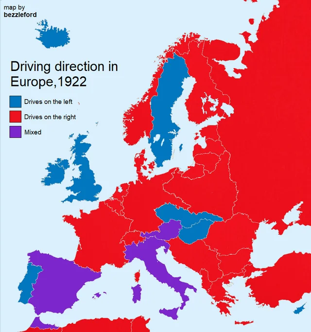
Italy, Spain and Austria are in purple. “Mixed” means that there was a mix of left and right in various regions of the country.
I think the question is asking for an explanation of how that is possible that some areas are right and some are left within the same country. Does the local government decide (city, state, etc), or is it something else, and why.
Additionally, they seem to be partially color blind, since they can't differentiate the purple from blue.
Edit: Copying my other comment here, based on some light Internet research which may or may not be accurate.
Austria was apparently split based on which part of the country was controlled by Napoleon, and this lasted for quite awhile, though a few sources cite different lengths of time for the mixed driving laws. I wanted to use a local source here but it was paywalled.
Also, apparently Italy and Spain (and Canada?) changed from left side to right side drive in the 1920s, so this probably reflects that change in Europe.